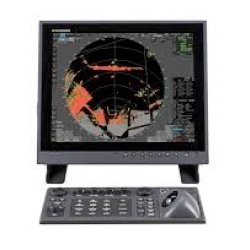
Description
The Electronic Chart Display and Information System (ECDIS) is a geographic information system for voyage planning and route monitoring to support the safety navigation of ships at sea.
The ECDIS onboard a ship uses images obtained from the automatic identification system (AIS), radar system, and collision avoidance target tracking (TT) system and superposes the images with navigational chart information, thus accurately displaying dynamic information on other ships around. Also the ECDIS plays central roles in the safe navigation of the ship and provides safety functions, including the generation of warnings when the ship approaches dangerous areas. The ECDIS is useful for marine accident avoidance and serves as equipment indispensable to the safe navigation of ships.